Emre Özdemir

PhD Candidate in 3DOM Unit, Digital Industry Center at FBK
Emre Özdemir is a joint PhD student at 3D Optical Metrology Unit of Bruno Kessler Foundation (FBK – Trento, Italy) and Skolkovo Institute of Technology (Skoltech – Moscow, Russia). His research interests include photogrammetry, machine learning, point cloud processing, image processing, and geographical information systems.
Emre has his MSC degree from the Department of Geomatics Engineering of Izmir Katip Celebi University on the topic ‘A Stereophotogrammetric Approach for Driver Assistance Systems’ in 2015. He has his BSc from the Department of Geomatics Engineering of Istanbul Technical University on the topic ‘GIS-Based Aeronautical Chart Project’ in 2012.
Recent Publications:
Özdemir, E.; Remondino, F.; Golkar A., 2021, An Efficient and General Framework for Aerial Point Cloud Classification in Urban Scenarios, Remote Sensing
Farella, E.M.; Özdemir, E.; Remondino, F., 2021, 4D Building Reconstruction with Machine Learning and Historical Maps, Applied Sciences
Özdemir, E., Remondino, F., and Golkar, A., 2019: Aerial Point Cloud Classification with Deep Learning and Machine Learning Algorithms, ISPRS Archives, GeoSpatial Conference 2019 – Joint Conferences of SMPR and GI Research, 12–14 October 2019, Karaj, Iran
Özdemir, E., Toschi, I., Remondino, F., 2019: A Multi-Purpose Benchmark for Photogrammetric Urban 3D Reconstruction in a Controlled Environment, ISPRS Archives, Workshop on the Evaluation and Benchmarking Sensors, Systems and Geospatial Data in Photogrammetry and Remote Sensing, 16-20 September 2019, Warsaw, Poland
Özdemir, E., Remondino, F., 2019: Classification of Aerial Point Clouds With Deep Learning, ISPRS Archives, Geospatial Week, 10–14 June 2019, Enschede, The Netherlands
Özdemir, E., Remondino, F., 2018: Segmentation of 3D Photogrammetric Point Cloud For 3D Building Modeling, ISPRS Archives, 13th 3D GeoInfo Conference, 1–2 October 2018, Delft, The Netherlands
Articoli Spotlight
-
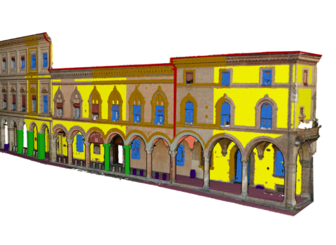 14 Giugno 2021Classificazione di nuvole di puntiSono in grado di rappresentare forma, dimensione, posizione e orientamento di oggetti e scene nello spazio per applicazioni quali la modellazione 3D della città, il monitoraggio del territorio, l'ispezione delle linee elettriche, la navigazione autonoma in spazi indoor e outdoor, il monitoraggio industriale, la documentazione e il restauro del patrimonio culturale