Urban climate shelters with TALEA: design and participation to counter heat islands
July 23, 2025
In Bologna, a data-driven approach—combined with citizen participation and environmental sustainability—is being used to enhance both climate resilience and social well-being in the city.
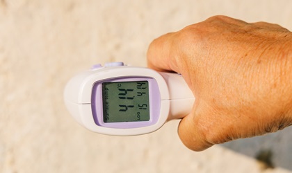
We often hear about it today, but what exactly are “heat islands,” and how can they be identified? Heat islands are areas in the city where, due to urbanization, more heat accumulates compared to surrounding areas. This phenomenon depends not only on surface temperature but also on factors such as humidity, ventilation, vegetation, and the materials used in urban infrastructure.
To address this issue, the Municipality of Bologna has adopted an innovative approach that combines technology, environmental sustainability, and social inclusion. This gave rise to the TALEA project, developed in collaboration with the University of Bologna, the IU Rusconi Ghigi Foundation of Bologna, Trento-based Fondazione Bruno Kessler, and other Italian and European partners. The initiative involves the creation of urban climate shelters and corridors—cool, accessible public spaces designed for citizen well-being, featuring shaded, safe routes for access.
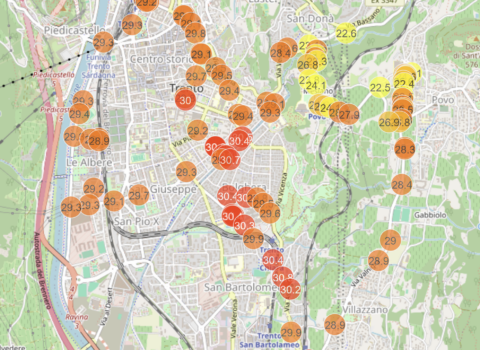
TALEA is a four-year project through which Fondazione Bruno Kessler, alongside other partners, is currently defining the most effective methods for identifying and monitoring heat islands. This involves integrating multiple data sources, from satellites like Landsat—which has long observed Earth’s surface, providing information on temperature and land use—to data from city and regional climate stations, as well as local surveys and field measurements.
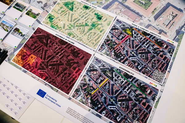
“We started with what satellite data tells us,” Maurizio Napolitano, coordinator of the Digital Commons Lab at the FBK Center for Digital Society, explains.“In particular, we analyzed 2024 summer data from Landsat, which estimates surface temperature in 100-meter cells. In addition to temperature, we also calculated surface reflectivity (albedo) and the vegetation index, which help us better understand the thermal behavior of different urban areas. This gave us an initial map showing where heat tends to accumulate and dissipate more slowly. It’s already a useful analysis, which we will further refine by cross-referencing with other data sources and the contributions of various partners, combining technical expertise with knowledge of local needs and conditions.”
The data collected through satellites makes it possible to identify recurring features that indicate heat-vulnerable areas. As is well known, vegetation helps reduce temperatures, while reflective surfaces prevent heat accumulation. The goal is to create more livable and inclusive public spaces, tailored to the environmental, social, and cultural characteristics of each site.
Urban redevelopment—especially in complex contexts such as historic city centers—requires administrations to make well-informed and specific choices.
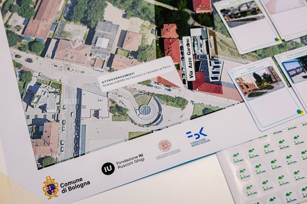
Through the TALEA project, a participatory urban design process has been launched to improve the climatic and social quality of public spaces. Planned interventions will target key areas of Bologna through a co-design process involving residents.
Design proposals will be discussed with planners, environmental experts, and citizen groups, with particular attention to the purposesof each space and the vulnerabilities that must be addressed. The impact of these interventions will be monitored using accessible digital tools, allowing for transparent, long-term evaluation.
“Monitoring will be managed by Fondazione Bruno Kessler, integrating the expertise and outputs of all scientific and technological partners,” Napolitano said. “The goal is to make the tools developed throughout the project usable and shareable. Some of them may even be incorporated into Bologna’s Digital Twin services—a project led by Marco Pistore, head of the MOST(Modeling and Simulation of Techno-Social Systems) Unit at the FBK Center for Digital Society.”
Great emphasis is placed on replicability, encouraging the use of open data—such as Landsat-based analysis—to promote transparency and adaptability in other urban contexts. The project also includes collaboration with cities such as Cluj-Napoca (Romania), Marseille (France), and Riga (Latvia). The aim is not only to export tools but also to share citizen engagement practices that can be adapted to other urban environments.

Il progetto TALEA – Green cells leading the Green transition (EUI102-064) è co-finanziato dall’Unione Europea nella cornice del programma European Urban Initiative – Innovative Actions (EUI-IA). Le opinioni espresse appartengono al solo o ai soli autori e non riflettono necessariamente le opinioni dell’Unione europea o dell’European Urban Initiative (EUI). Né l’Unione europea né EUI possono esserne ritenuti responsabili.
Foto di Massimiliano Donati per Fondazione IU Rusconi Ghigi.
The author/s
Related articles