
RUMA: digital technologies to transform forest monitoring
April 22, 2026
A project developed with FBK enables sustainable forest management by making it possible to monitor large areas with a level of precision and scalability that was previously unattainable.
In the context of growing attention to environmental sustainability and digital innovation, the startup RUMA introduces an advanced approach to forest monitoring. It develops digital solutions based on a Software as a Service (SaaS) model, capable of significantly transforming how forest areas are analyzed and managed.
An innovative company affiliated with the University of Trento, RUMA collaborated with Fondazione Bruno Kessler as part of the EDIH-SoE InnovAction initiative. The project, co-funded by the Ministry of Enterprises and Made in Italy (MIMIT), enabled several Italian SMEs to access “Test Before Invest” services offered by the partners. In this context, the collaboration with the 3DOM unit of FBK’s Center for Digital Industry aimed to overcome the limitations of traditional manual surveys by introducing a digital system capable of speeding up operations, reducing time and costs, and significantly improving the quality and comparability of data over time.
From manual collection to digital monitoring
Traditionally, forest monitoring relies on surveys carried out manually by field technicians—a process that is time-consuming, costly, subjective, and difficult to replicate accurately over time. RUMA proposes to overcome this approach by transitioning to a fully digital system based on the integration of satellite imagery and data collected via drones or aircraft.
In this scenario, the use of LiDAR (Light Detection and Ranging) technology, combined with artificial intelligence (AI) algorithms, enables highly precise analysis of forest areas in significantly less time. The three-dimensional data obtained through LiDAR makes it possible to extract detailed information such as the number of trees, their height, canopy size, and other key characteristics for vegetation analysis. RUMA has already developed EcoSense, a platform based on Sentinel satellite imagery, designed to monitor and certify the effectiveness of reforestation projects. The integration of high-resolution LiDAR data, collected via drones or aircraft, represents a significant evolution of this system, increasing the value of the services offered.
This integration not only improves the efficiency and accuracy of analyses but also enables the creation of a historical database capable of tracking forest evolution over time, supporting multi-temporal studies that were previously difficult to achieve.
Methodologies and technological development
The project activities were structured in several phases, starting with the analysis of technical requirements for LiDAR surveys using drones, and continuing with the collection and annotation of datasets needed to develop AI algorithms. A key element is the processing of LiDAR point clouds using deep learning techniques, which enable semantic classification of the data and automated extraction of forest parameters. This approach makes it possible to obtain accurate, repeatable data that can be directly used for sustainable ecosystem management.
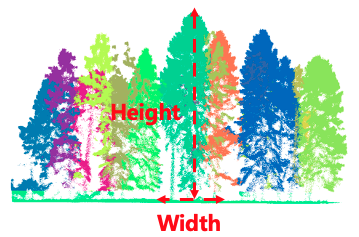
FBK, and in particular the 3DOM Unit of the Center for Digital Industry, in collaboration with the company, began by defining the technical requirements for the acquisition, processing, and validation of LiDAR data, establishing a comprehensive methodological framework for digital forest monitoring. Next, datasets were collected and structured for the development and validation of the methods. Finally, the effectiveness of the developed algorithms was tested, demonstrating how detailed and reliable information can be extracted from LiDAR point clouds thanks to artificial intelligence.
Toward a new approach to forest management
RUMA’s approach opens new perspectives for the forestry sector, making it possible to monitor large areas with a level of precision and scalability that was previously unattainable. The combination of drones, LiDAR sensors, and artificial intelligence provides a practical solution to address challenges related to ecosystem conservation and climate change.
As Fabio Remondino, head of FBK’s 3DOM unit, explains, “the deep learning methodologies we developed were validated on LiDAR data acquired at different densities and in various forest contexts, in order to account for a range of possible scenarios. At present, deep learning clearly provides strong support to the forestry sector, delivering automated, scalable, objective, and detailed analyses. Greater collaboration among companies, researchers, and end users would further improve these solutions in support of a sector facing multiple challenges due to climate change. ”
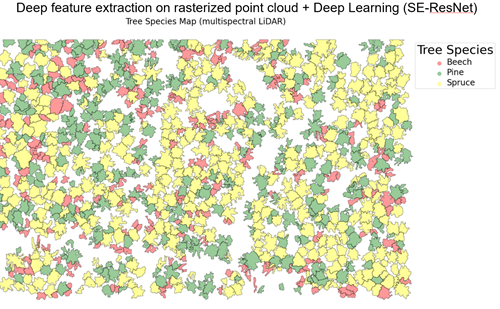
Through technological innovation, RUMA is helping to build a more efficient, sustainable, and forward-looking model of forest management.
The author/s
-
 Fabio Remondino
Head of Unit 3D Optical Metrology (3DOM), Digital Industry Center -FBK
MORE INFO
Related articles